
Supercells develop near I-40 in western Oklahoma along an outflow boundary, then move south and provide some of the best structure of the year.

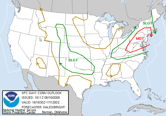
This June is turning out to have some uncanny similarities to last, with almost-daily convection across the Southern Plains; I'm just hoping it doesn't lead to another insuffrable, muggy, bug-ridden summer as a whole! In any case, this was yet another in a long, long string of SLGT risk days around the region with the usual expectations: isolated to scattered storms developing by mid to late afternoon, some possibly supercellular, before congealing into a big MCS mess by evening. Other than nice directional shear (NW flow aloft with strongly backed low-level winds), nothing really stood out about today over any of the other convective messes recently. Fortunately, an outflow boundary that would focus convection was located right along I-40 in OK, so I'd get a chance to chase without going too far if there was any boundary magic. By 3:00, a small MCS was ongoing across north-central into east-central OK, but a couple isolated cells were rapidly developing near the OFB around Clinton and Weatherford. Within 15-30 minutes, they appeared plainly supercellular on radar, and I was running out the door from work in a near-panic (a common theme so far this summer). I went back home to pick up my gear, and Bryan and I were off to the races in my car.
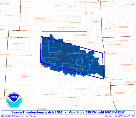
Last I'd seen, the storms were moving a bit south of due east; this was good, I thought, since my hope was they'd anchor along the OFB and possibly spin up a tornado or two, much like June 13 last year. With that in mind, we raced north on I-35, planning on taking I-40 west towards the storm. But with the first radar update we looked at, it was apparent we had a problem: the beautiful supercell now near Weatherford had turned right and was moving almost due south! Crap. We got off at I-240 westbound, then took OK-152 via Airport Rd. to Union City. From there, down to Minco and continued west on OK-152 all the way to Binger, still not far enough west to see the base! I was running very low on gas, so we refueled in Binger for an outrageous price (over 20 cents higher than in Norman). Then we dropped south and west to Carnegie to circumvent the core of our storm, but by the time we arrived, it was weakening substantially on radar; plus, despite a really long and cool-looking inflow tail stretching west out of the southward-moving storm, the entire base and area of interest was socked in with rain. But now, there was a new tornado-warned supercell a bit farther to the SW near Cordell. I was glad we still had a play despite our initial storm dying, yet extremely frustrated to still be playing catchup after what had already been a stressful drive.
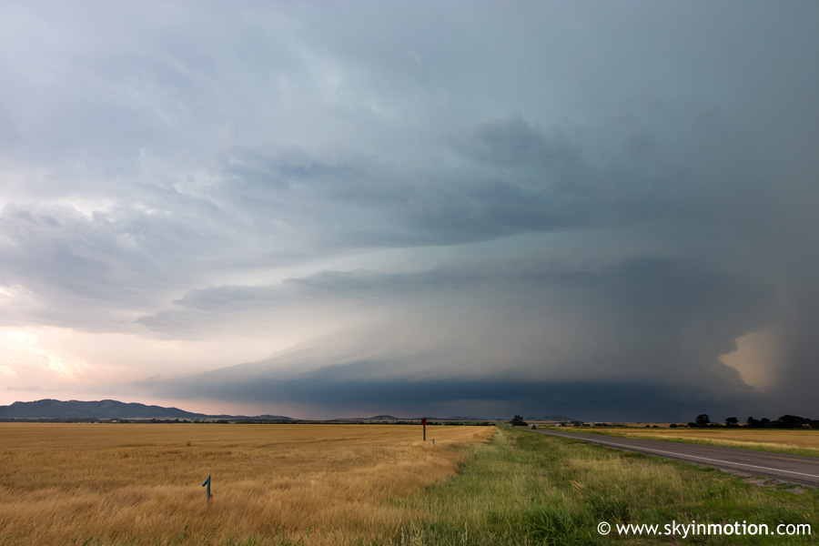
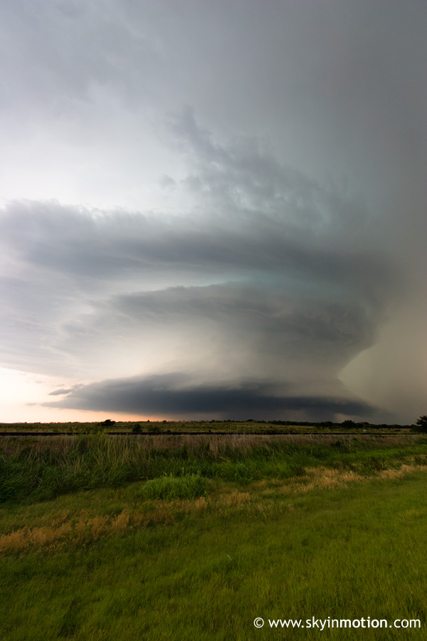
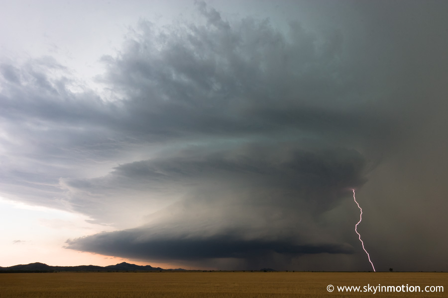
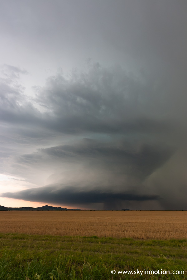
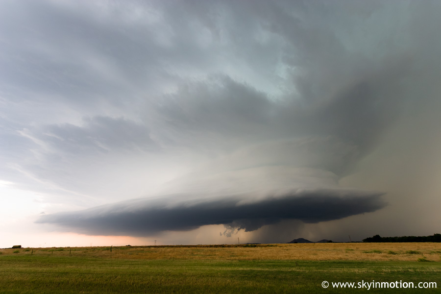
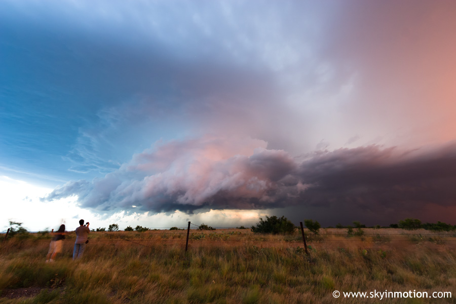
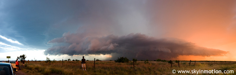
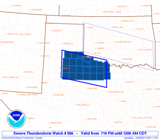
This season has really been an eye-opener for me in terms of how I correlate radar presentation of a storm with structure and tornado potential. In the past, I've ignorantly written off just about anything that isn't a classic, totally discrete, flying-eagle type supercell on radar as being "messy" and not worth pursuing. Well, this storm we were now going after looked fairly messy - despite a nice inflow notch, there was tons of convection stretching back to its north and west, so I wasn't getting too excited. We continued west out of Carnegie on OK-9 to Gotebo, dropped south on OK-54, then turned west onto OK-19 to witness the most amazing supercell I've ever seen sitting straight ahead on the road.
There's really not much that can be said, so I'll just get to the pics. It never appeared that close to producing a tornado, despite a couple half-hearted wall clouds. CG lightning activity was simply prolific, and we witnessed at least one grass fire as a result of this. We followed this monster south for about an hour as it meandered parallel to US-183 just to our west.
It sure was a shame to see this finally start to weaken as it moved into Tillman Co. We stopped briefly in Frederick to pick up dinner at Subway; just before we went in, a tornado warning was issued for a new cell to the SW, so I was probably biting my nails off as we stood in line behind two locals takin' their time and makin' sure to slowly and thoughtfully pick out every veggie in existence for their sandwiches. Then we finally get to ordering ours, and the freaking power goes out, causing further chaos. Anyway, about 15 minutes later, we were finally back in the car and seeing that fortunately, the new storm was still not that far to our SW. We blasted south to US-287 in Wilbarger Co., at which point the storm was about 15 miles to our WSW. It appeared Vernon would just barely be spared the massive hail core by being just far enough east, so we started to head west into town so we could drop south from there. Not a mile into the drive, the sporadic areas of blowing dust that had been occurring all evening went from amusing to disconcerting: there was now a wall of red dirt being pulled into this monster supercell, so much so that most of the vehicles around us started pulling off the road. Visibility was getting down to 50-100 yards at best, so I eventually followed suit and pulled off. A couple minutes later, a truck went flying by, and I decided we'd just stay on his tail and hope for the best, lol. Of course, it turned out that the "dust wall" ended only about a quarter mile past where we'd pulled off, so we pressed on to Vernon, then dropped south on US-183.
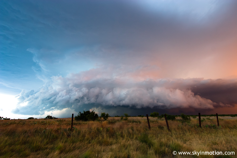
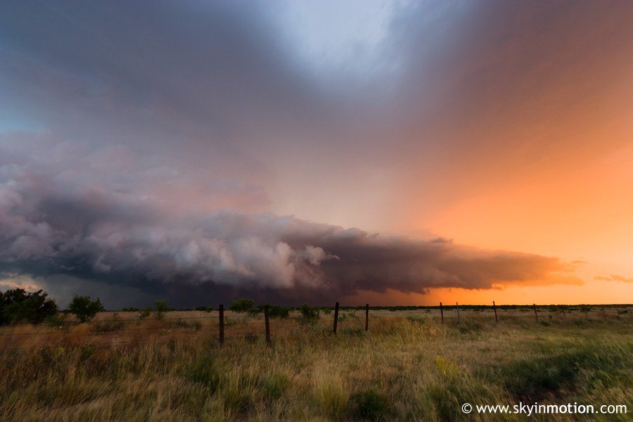
It took a bit of effort to get far enough south that additional blowing dust wasn't obscuring our view of the base, but when we finally did, it didn't look very promising tornadically. Instead, we were dealing with a very large HP beast whose rotation was concealed well within the core. We followed it down to the Wilbarger-Baylor Co. line, where we pulled off to say hello to Gabe Garfield and a few others and admire the structure with sunset lighting.
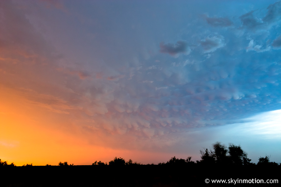
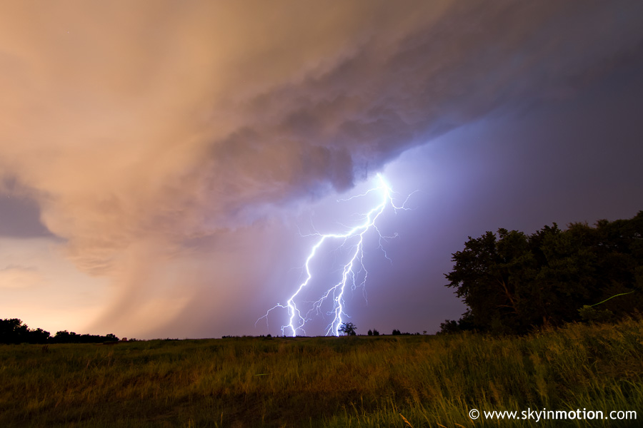
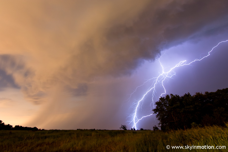
With darkness, we called it a day and made it home by 11:30 or so. On the way, I could see quite a bit of lightning with elevated storms around the OKC area, so after we got back I went out for a quick attempt at lightning photography. A fairly weak storm developed just east of Moore, and was moving due south on a path to cross just a couple miles east of my apartment. I found an open field about 2 mi. E of my apartment along OK-9 and did long exposures looking to the north until a bolt finally hit. This was shot at 12 mm, so you can imagine the sound that followed this!
(I actually ended up with two keepers, the second rather similar to this - but it was snapped just after midnight, giving it a 2008-06-17_ filename, and my PHP code is currently set up to assume a filename consistent with the chase date... way more than anyone wanted to know, no doubt, but you can see it here).


