Historic tornado outbreak over much of the High Plains; I catch a photogenic tornado near Brice, TX.
Observed 3 tornadoes.
Incredible March outbreak over the High Plains all the way from West Texas to Nebraska. This was easily the largest tornado outbreak in several years for this region! Granted, that's not saying much after 2005 and 2006, but who would've thought all the ingredients would come together to break the tornado drought in such a spectacular fashion in March?
The system responsible for the tornadofest was quite well-forecast in a general sense, with the threat showing up on the medium-range model runs and ensembles as early as ten days prior. Of course, the devil was in the details. As we came within a few days of the event, the models began slowing the system somewhat and trying to close off an upper-level low over the Rockies. This was concerning, as upper-level winds would then become more meridional (more southerly than westerly), decreasing directional shear and posing the risk of linear storm mode. Ultimately, the trough was indeed rather sharp and a closed low did form, but nicely backed surface winds proved sufficient for a dream early-season chase day. Incredibly, despite the calendar month, surface moisture was so ample as to not even be a big concern, and CAPE values of 2000-4000 J/kg reflected the advantage of having widespread, fairly vertically deep 60-65 degree dewpoints over the target area.
The big question even as late as the morning of was whether storms in the northern target near the triple-point (W NE, NW KS) or the southern target along the dryline in better moisture (TX PH, W OK) would be more favorable for tornado production. Personally, I never really considered the northern option because of time concerns being that it was the middle of the school week, so I just kept my attention focused on the southern dryline target in the days leading up to the event. I think I speak for most everyone here in Norman when I say the 24-48 hours before the outbreak provided an awesome build-up of excitement, with each new model run seeming to show more backed surface flow and higher instability over W OK and the TX Panhandle. By the 00z Wednesday runs, the forecast soundings made a mockery of those who had claimed the hodographs looked too linear for a tornado threat, as strongly clockwise-curved hodographs were showing up over the same region as 3000-4000 J/kg of CAPE and weakening CIN through the course of the afternoon. Game on.
The anticipation reached unbearable levels by Wednesday morning, with most of us "serious" chasers running on adrenaline after little or no sleep, and even a lot of the meteorology students who normally have little interest in chasing trying to figure out carpool plans. After our 9:00 AM meteorology class, Bryan, Brandon and I raced home and checked the latest data. I was not pleased with the suddenly increased capping on the 15z RUC, which sent me into a brief dismissive rant I would later regret. In any case, we headed out by 11:30. Brandon and Bryan had set their eyes on Elk City, while I was leaning more towards Altus based on model output. We had enough people tagging along that we were going to need to split up into two cars anyway, so Aaron Gleason and Ilya Neyman "sided" with me and we hit I-44 in my car, while Brandon, Bryan and another meteorology student they picked up opted for I-40 west.
After a Wal-Mart stop in Lawton to pick up some video tapes, we continued west to Altus, where we noted a concerning layer of cirrus moving in from the west. We checked data again, then picked up lunch at Burger King and refueled my car. At this point, things still appeared quesitonable given the widespread cirrus showing up on the visible satellite shot over much of W OK and the E TX Panhandle. Temperatures were already well into the 70s, but I knew the clouds could still spell trouble, especially given the warmer 850 mb temperatures on the morning model runs. We pressed westward on US-62 to Hollis with cautious yet hard-to-control anticipation, anticipation, which went through the roof upon hearing that a PDS Tornado Watch had been issued for the entire TX Panhandle. It was fairly interesting that the dryline was positioned significantly farther west than even the short-range models had predicted, forcing us deeper into the Panhandle, just like the Feb 23 chase in the same region.
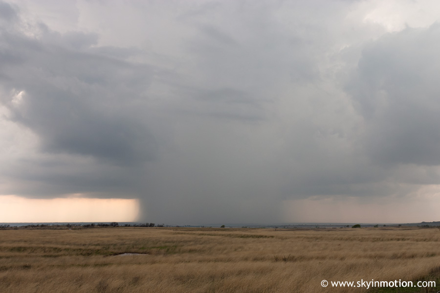
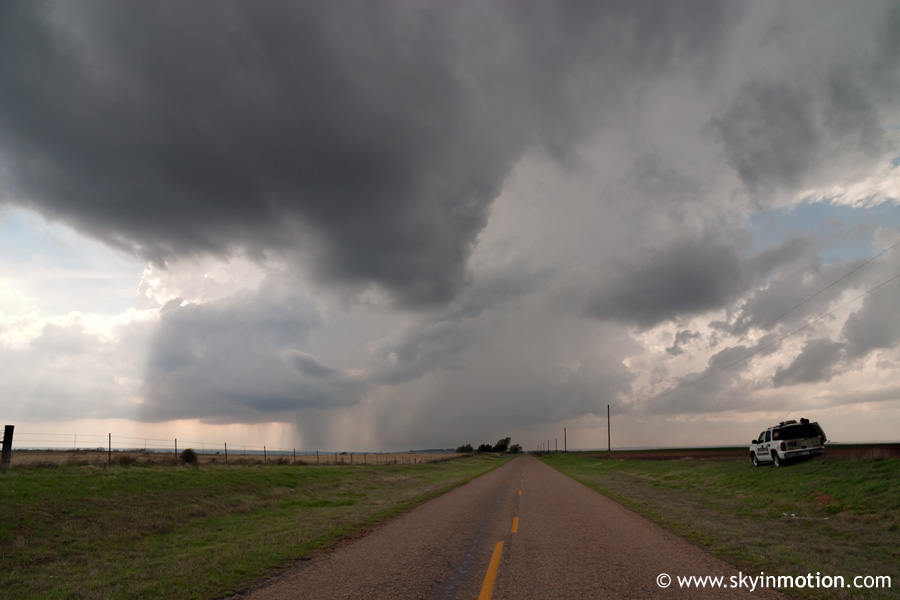
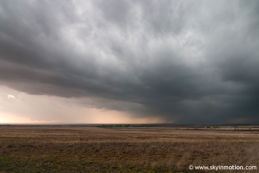
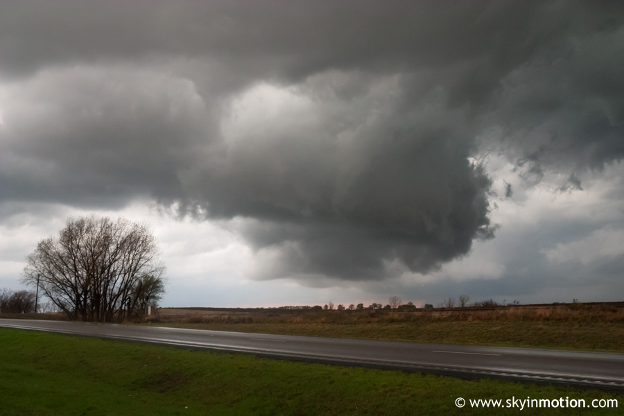
By this time we knew almost every other OU chaser had chosen the I-40 route and wound up at the Best Western in Shamrock, and I was somewhat interested in getting up there to meet up with everyone else if nothing erupted soon - I guess I've still got a ways to go before I feel even remotely comfortable making critical decisions without the guidance of either radar or more experienced chasers. So when we reached US-81, I was pretty set on heading north, despite some disagreement amongst ourselves. At the time, we were watching a tower explode to our west, adding to the tenseness of the situation. We eventually agreed that moving north at least to Wellington (where wifi was available) seemed reasonable, especially since the developing Cb was headed north-northeastward. We made a quick pit stop and data check at a gas station in Wellington and watched the storm paralleling us to the west develop a nice base, so we continued north. About halfway to Shamrock, the storm became so photogenic with its hard rain/hail shaft and large anvil that we had to pull off on a backroad to get an unobstructed view.
As luck would have it, a news van from KFOR (Channel 4) in Oklahoma City was parked on the same road. They turned out to be a team led by David Payne, who was very friendly and allowed us to look at their live radar data.
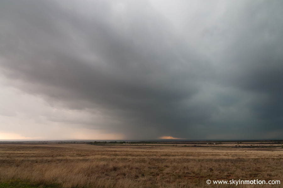
We stuck around watching the supercell pass to our west for a good half hour; the news crew's radar showed substantial weakening as the storm split, and new towers were appearing to our south, so we didn't have a good reason to go any farther north. A little after 5:00, the news crew got very excited about developments on radar well to our south-southwest - we took a look and noted a couple very impressive and rapidly-strengthening supercells over the southern TX Panhandle. The news van took off, and we decided to follow suit a few minutes later.
This is where things finally start to get interesting. We knew the cell was now tornado-warned and located in northern Floyd County, nearly 75 miles from our current position north of Wellington. While I focused on driving as quickly as possible without getting into trouble, Aaron flipped through the maps and determined that our best route was down US-81 to TX-203, where we would head west to Hedley. We did just that, and then took US-287 northwest to Clarendon. I was a bit surprised at the lack of a truly ominous sky to our west by that time, which was mainly because the entire sky was covered by anvils from the multiple supercells in the region, precluding the type of contrast you might expect coming up on a tornadic storm. On the radio, we heard reports of a tornado on the ground in South Plains doing damage, in addition to another to the north in Briscoe County near Silverton.
After turning onto TX-70 southbound and driving a few miles, we crested a hill that offered up a sudden, clear view of both supercells! We pulled off on the shoulder with numerous other chasers and alternated our attention between the Silverton storm off to our west, which had a large, dark precipitation shaft obscuring whatever tornado may have been occurring, and the South Plains storm to our south-southwest, which featured a well-defined, large wall cloud easily visible even from our distance of 15-20 miles away.
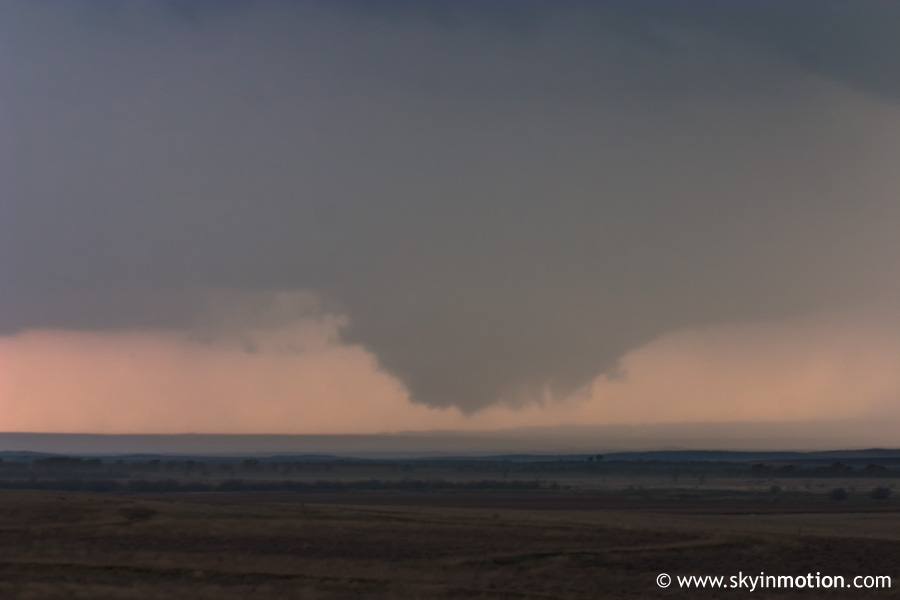
A few minutes later, we were reuinted with Brandon and crew at last as they caught up and stopped at the same spot. Everyone photographed or videotaped intently for 10 or 15 minutes as the wall cloud on the southermost cell grew more impressive, then began making funnel attempts. We couldn't tell for sure whether any funnels reached the ground from our distance, but judging by other chaser reports and video, I think it's safe to say we were witnessing the beginning stages of the now-infamous Turkey/Brice tornado we would soon be seeing for ourselves.
I still don't know exactly what we were thinking, but we all severely underestimated the distance between us and the storm, and figured we'd be set just waiting there on the hill and letting it approach us. However, Aaron and I grew more and more concerned as it appeared a tornado was likely about to occur and the storm was not approaching us in any big hurry, so eventually we threw our stuff in the car and flew south to the TX-70/TX-256 junction, where nickel to quarter size hail began affecting us. Meanwhile, the storm was continuing its north to north-northeast motion at about 30 mph, so the funnel-producing wall cloud was now close enough for a good view, much to our delight.
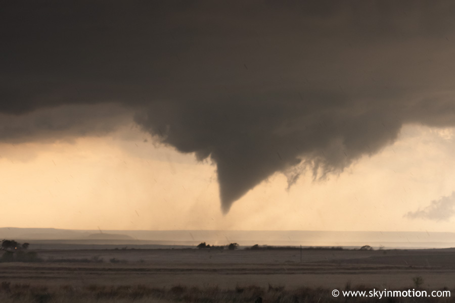
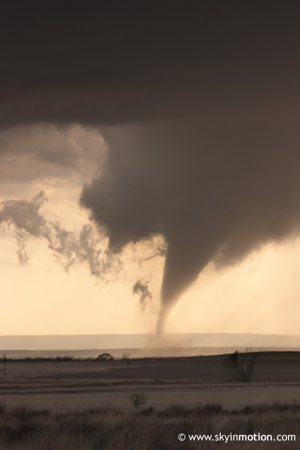
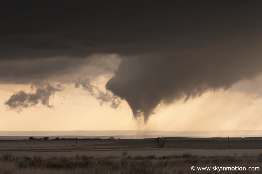
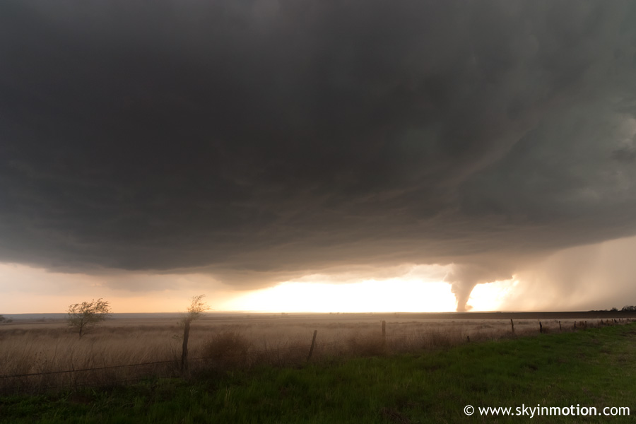
Remember how I said I'm still not too comfortable making big chase decisions? Well, what I did next surely erased whatever confidence I had built up so far this day. At the TX-70/TX-256 intersection, I decided in haste to make a left and get a mile or two farther east so we could have a shot at watching without heavy rain and hail ruining our photography/videography efforts. Once again, this was due to my tendency to majorly underestimate the distance between myself and a feature of interest. At this point, the funnel was probably still a good 8-12 miles to our southwest, but to me, it appeared closer, and far enough east that it would be in danger of crossing TX-256 back to our southwest (where we could've gone if I'd made a right at the intersection instead). No more than 20 seconds after I made that fateful left turn, the wall cloud began to drop another funnel that looked far more ominous than what we'd seen before, and it touched down as a tornado quickly thereafter. I pulled over at the soonest clear spot I could find, and we jumped out of the car (with a modest amount of hail still pelting us) and went crazy. Being my usual self, my celebration only lasted long enough for me to whip out the camera and begin shooting intently.
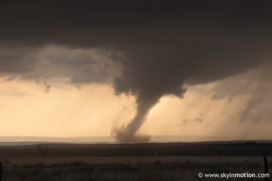
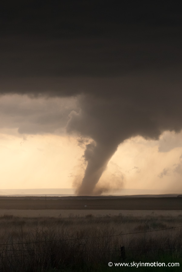
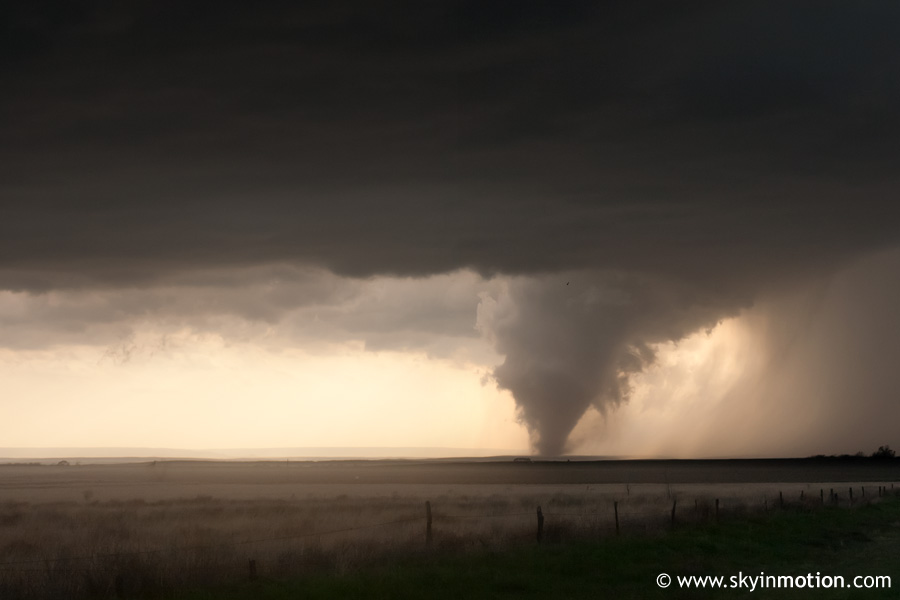
As the tornado churned across open territory, evolving from a nice cone initially to a fairly sizeable stovepipe at its peak, I continued to underestimate our distance from it, oblivious to the fact that we probably should've been hauling back west for a true up close and personal intercept.
In reality, we were viewing the tornado from about 4 to 6 miles away, whereas just about everyone else and their mother farther down the highway southwest of Brice was more like 2 to 4 miles away. A small consolation is that our position was slightly higher and offered a view free of many trees, unlike those in the river valley down the road.
Eventually, we realized it would be stupid not to try getting a little closer, so we backtracked, finally stopping about a mile southwest of the intersection to watch the rope-out. I scrambled to pull out my camera again, but excruciatingly, it was giving me trouble and wouldn't turn on, probably thanks to my subjecting it to rain and hail for a good 10 minutes at our first stop. I then proceeded to totally waste the stellar view we had of rope-out stage by frantically trying everything I could think of to fix the stupid camera, to no avail. By the time it was working properly again, the rope was all but gone, and I had surely missed dozens of amazing shots. But even worse, I hadn't even watched it, and in hindsight, I should have at least enjoyed the once-in-a-lifetime view without worrying about the gadgets. Sometimes I think I get a little too caught up in photography while chasing, to the point where bringing back good photos is even more important than actually experiencing severe weather. And I guess it's justified in some sense, because while the sensory experience of a good storm is uniquely intense and satisfying, it isn't permanent or concrete, whereas pictures are. But still, this was a good (or not-so-good, I should say) example of how it can occasionally really screw things up.
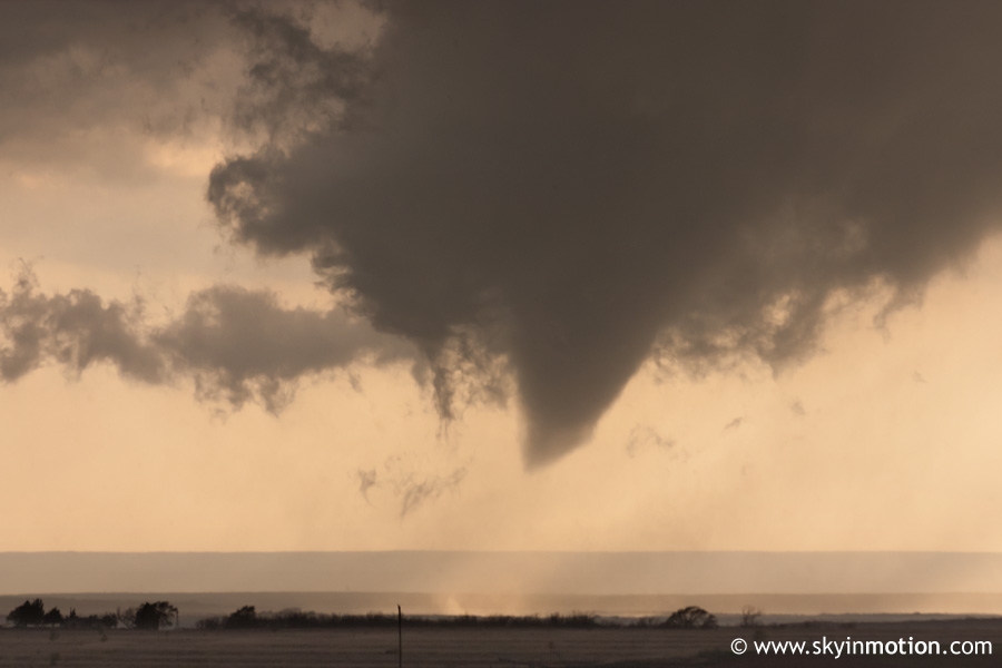
It wasn't until later that it hit me just how amazing this tornado really was. Even from our slightly distant view, I could tell it reached a pretty impressive width at its peak, but I certainly didn't realize just how wide until I later saw some of the video taken close up from the south side of the tornado, at which point I nearly had a heart attack! Man, this thing was a beauty, and pretty large and (likely) strong to boot. Plus, the rope-out was about as good as it gets, with great coloration and a wide arc shape.
And I can't possibly neglect mentioning the storm structure through the duration of the tornado. Being the huge fan of photogenic supercells I am, I'm half-tempted in my most daring moments to say it's a shame the tornado was there to distract our attention from the storm! Seriously though, the striated mothership appearance of this beast of a rotating supercell was by far the best I'd seen, and would have been more than sufficient on its own to justify the four-hour drive to the Caprock!
Most of the rest of the evening is a blur, and I'm sure very few readers are still with me at this point anyway, so I'll try to keep the rest brief. We followed TX-70 back north towards Clarendon, immediately encountering heavy traffic resulting from the nightmarish chaser convergence. Judging by radar data I looked at after the event, a long, broken line of supercells was now present over the central TX Panhandle by this time, and given that we had no live data, things became very confusing from a visual standpoint. In the end, it didn't matter much, as everyone was headed the same way (northward) in a miles-long stream of chase vehicles, and it was more a matter of getting past idiots slowing down to gawk and stopping in the highway to setup their tripods than actually determining the best route. On our way from Brice to Clarendon, the storm continued to exhibit impressive structure with lowerings and funnel attempts, but never managed to produce again, at least that I could see.
One noteworthy roadblock we hit, quite literally speaking, was that US-287 was blocked off just east of Clarendon when we arrived, apparently because local law enforcement deemed the weather situation too dangerous to allow vehicles to get any closer to the wall cloud, which was well to our east.
Predictably, it was only a couple minutes before a long line of enraged chasers backed up all the way to the intersection with TX-70, and a few minutes later the "dam" burst open as they let us through.
As daylight faded, we made our way east to Hedley and then north towards McLean, with the new supercell to our north becoming very impressive. Unfortunately, we were simply crippled by the traffic and plethora of idiots driving and parking as if they owned the road, so we were kept just far enough behind the meso that we never got a definitive view of the multiple tornadoes that occurred near McLean during the late evening. One of the tornadoes crossed I-40 and overturned tractor trailers; hearing radio reports of this and the tornado's projected path, we raced eastward upon reaching I-40, hitting US-81 northbound at Shamrock. We made it a considerable distance north, past Wheeler, and observed a tornado to our west in southern Hemphill County during lightning flashes. Soon thereafter, it looked like the storm mode was finally trending towards linear - not that we could complain after several solid hours of incredible supercellular activity! So we turned around and headed for home in a state of near-disbelief. We stopped in Erick for Subway with Bryan and Brandon and took our time eating and exchanging stories about what we'd seen in each car. Finally arrived back in Norman by 1:45 AM or so, but it would still be several hours before any of us could pull ourselves away from pouring over pictures, video, and data to get some sleep. I skipped my 10:30 math class the next morning to "sleep in" until past 11, and still didn't get more than five hours of sleep!